



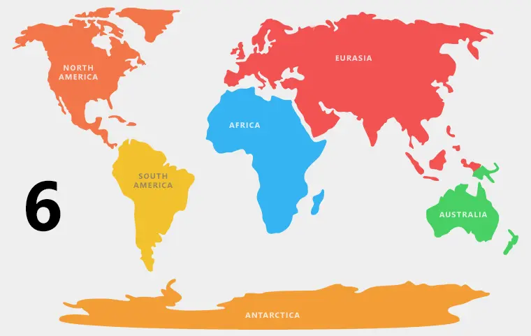
Earth can be classified as having six continents instead of seven when Europe and Asia are combined into Eurasia. The six-continent model is an established geographic classification, not a new scientific discovery. The traditional seven-continent model remains widely used, depending on educational and geographic conventions.
KumDi.com
For generations, students have learned that Earth has seven continents: Africa, Antarctica, Asia, Europe, North America, South America, and Australia. However, geological research suggests that this familiar classification is not the only scientifically defensible way to divide the planet. Some scientists argue that Earth can be described as having six continents rather than seven because Europe and Asia form one continuous landmass called Eurasia. Other geological research raises a more fundamental question: should continents be defined by their visible land, their underlying crust, or their geological history?
The important distinction is that scientists have not universally replaced the seven-continent model with a six-continent model. The number of continents depends partly on the definition being used. In physical geography and education, Europe and Asia are often treated as separate continents because of historical and cultural conventions. In geology, their connected landmass and complex crustal history make the distinction less straightforward. Research into continental formation, plate tectonics, and submerged continental crust demonstrates why the traditional seven-continent model is useful but not an absolute scientific rule.
Table of Contents
What Does It Mean That Earth Has Six Continents?
A continent is generally understood as a large, continuous landmass, but there is no universally accepted scientific definition that establishes one fixed number of continents for every purpose.
Under a common six-continent model, Europe and Asia are combined into Eurasia, producing the following list:
- Africa
- Antarctica
- Australia
- Eurasia
- North America
- South America
This classification treats Europe and Asia as two geographic and cultural regions of one continuous continental landmass. It is used in some educational and geographic traditions, although other six-continent models combine North and South America instead.
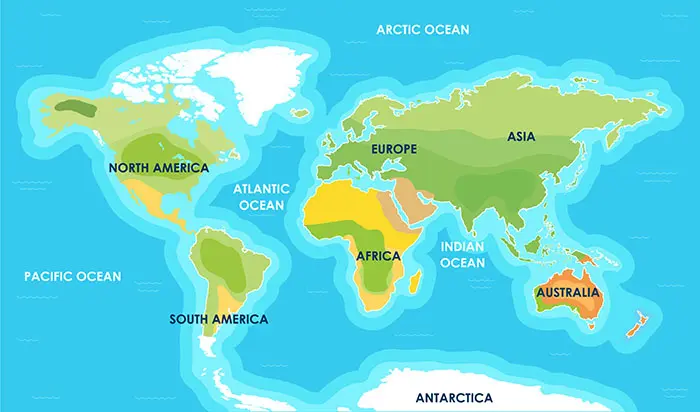
The seven-continent model remains widely used in English-language education. It separates Europe from Asia and North America from South America, resulting in seven named continents.
The key takeaway: Earth does not have a universally mandated number of continents. Six and seven are both established geographic classifications, but neither number should be presented as a newly confirmed scientific discovery that has overturned the other.
Why Do Scientists Disagree About the Number of Continents?
The disagreement exists because the word continent combines several different ideas. A map shows the visible surface of Earth, while geology examines the composition, structure, and history of the rocks beneath it.
Three major considerations help explain the debate.
1. Physical Geography: Continuous Landmasses
From a physical geography perspective, Europe and Asia are connected across a vast area of land. There is no ocean separating them completely.
Together, they form Eurasia, the largest continuous landmass on Earth. The boundary between Europe and Asia is conventionally drawn along features such as the Ural Mountains, the Ural River, the Caspian Sea, the Caucasus region, and nearby waterways, although the precise boundary varies among definitions.
This boundary is not equivalent to a clear, continuous oceanic separation. Instead, it reflects a geographic convention developed through historical mapping and regional classification.
For this reason, geographers who prioritize continuous landmasses may count Eurasia as one continent.
2. Cultural and Historical Geography: Europe and Asia as Separate Regions
Europe and Asia have long been distinguished in historical writing, political geography, and cultural traditions. Their separation has influenced education, cartography, and international descriptions of regional identity.
These distinctions remain meaningful even though the two regions share a continuous landmass.
For example, a geographic textbook may describe France as part of Europe and China as part of Asia. Combining the two regions into Eurasia does not erase their separate histories, cultures, political systems, or identities.
The six-continent model therefore changes the way continents are counted; it does not imply that Europe and Asia are identical or that their regional distinctions are invalid.
3. Geology: Continents Are More Than What We See on a Map
Geologists investigate the composition and structure of continental crust, which differs from the thinner, generally denser oceanic crust found beneath much of the ocean floor.
Continental crust is commonly rich in silica and aluminum-bearing minerals, although its composition varies considerably. It can preserve rocks billions of years old, records of ancient mountain-building events, and evidence of continents joining and separating over geological time.
From this perspective, a continent is not simply a large patch of land surrounded by water. Scientists may also consider the thickness, composition, age, and tectonic history of the underlying crust.
These geological characteristics make some continental boundaries difficult to define using a single simple rule.
What Is the Difference Between a Continent and a Tectonic Plate?
One common source of confusion is the assumption that continents and tectonic plates are the same thing. They are not.
A continent is a geographic or geological unit. A tectonic plate is a large, rigid section of Earth’s lithosphere, consisting of the crust and the uppermost mantle, that moves relative to other plates.
A single tectonic plate may contain continental crust, oceanic crust, or both. Likewise, a continent may extend across more than one tectonic plate.
Consider the following distinctions:
| Feature | Continent | Tectonic plate |
|---|---|---|
| Primary meaning | Geographic or geological landmass | Rigid section of Earth’s lithosphere |
| Main defining factors | Landmass, crustal structure, geological history, and convention | Mechanical behavior and plate boundaries |
| Relationship to oceans | Often associated with large land areas, but continental crust can be submerged | Can include both land and ocean floor |
| Movement | Not defined primarily by movement | Moves relative to other plates |
| Number | Depends on the classification system | Depends on how plates are identified and subdivided |
The Earth’s major tectonic plates include the African, Antarctic, Eurasian, North American, South American, Pacific, and Indo-Australian plates, although plate models differ in how they divide or group certain regions.
This does not mean that Earth has seven continents because there are several major tectonic plates. The two systems describe different aspects of the planet.
Does Geological Research Prove That Europe and Asia Are One Continent?
Geologically, Europe and Asia are connected across Eurasia, but determining whether they should count as one continent depends on the criteria being applied.
The Eurasian landmass contains a complex arrangement of ancient continental blocks, mountain belts, sedimentary basins, and tectonic zones. Its geological history includes the collision of landmasses, the closure of ancient oceans, and the formation of mountain systems.
For instance, the collision of the Indian Plate with Eurasia helped form and uplift the Himalayas and Tibetan Plateau. This process illustrates how continents and continental fragments can collide and reshape the Earth’s surface.
However, this geological connection does not establish that every scientific discipline must classify Europe and Asia as one continent. Geologists may describe crustal blocks, tectonic plates, or geological provinces without relying on the same continental boundaries used in school atlases.
The scientific conclusion is more nuanced than the headline: Eurasia is a continuous landmass, but whether Europe and Asia count as one continent is partly a question of classification rather than a newly discovered geological fact.
How Plate Tectonics Explains the Changing Continents
Earth’s continents have not always occupied their current positions. They have repeatedly joined together, fragmented, and moved over hundreds of millions of years.
The theory of plate tectonics explains these changes through the movement of lithospheric plates over geological time.
Step 1: Continental Crust Forms and Evolves
Continental crust develops through complex processes involving mantle-derived magmas, melting, volcanic activity, sediment accumulation, and the reworking of older rocks.
Unlike oceanic crust, much continental crust can survive for billions of years. Some of Earth’s oldest known rocks and minerals preserve evidence of early crust formation.
Step 2: Continents Collide
When tectonic plates carrying continental crust converge, their buoyant crust often resists being pulled deep into the mantle. Instead, the crust may shorten, thicken, fold, and rise to form mountain ranges.
The Himalayas are a modern example of a mountain system associated with continental collision.
Step 3: Continents Separate
Continental rifting occurs when continental crust stretches and thins. If rifting continues, the crust can split and new oceanic crust may form between the separating landmasses.
The opening of the Atlantic Ocean illustrates how continents that were once joined can become separated by an expanding ocean basin.
Step 4: The Geography of Earth Changes
Over millions of years, the positions and connections of landmasses change. Continents can collide to form larger supercontinents or separate into smaller landmasses.
Consequently, the present arrangement of six or seven continents represents one way of organizing today’s geography, not a permanent structure that has existed throughout Earth’s history.
Pangaea: When Most of Earth’s Land Was Joined Together
Pangaea was a supercontinent that brought together most of Earth’s major continental landmasses during the late Paleozoic and early Mesozoic eras. It began breaking apart roughly 200 million years ago, although the breakup occurred in stages and continued over an extended period.
The existence of Pangaea provides strong evidence that today’s continental arrangement is not fixed.
Several lines of evidence support the reconstruction of ancient supercontinents:
- Matching geological formations: Rocks and mountain belts on continents now separated by oceans can share related geological histories.
- Fossil distributions: Similar fossils occur in regions that are now geographically distant, helping researchers reconstruct ancient connections.
- Paleomagnetism: Magnetic signals preserved in rocks provide evidence about the historical positions and movements of continental blocks.
- Seafloor spreading: Ocean-floor patterns and magnetic stripes record the creation and movement of oceanic crust.
- Continental margins: The shapes and geological structures of continental edges help scientists reconstruct past configurations.
These findings explain why scientists distinguish the current geographic arrangement of continents from the geological processes that continually reshape them.
Zealandia: Is Earth Hiding Another Continent?
One of the most interesting developments in modern continental geology concerns Zealandia, a largely submerged region of continental crust in the southwest Pacific Ocean.
In a 2017 study published in GSA Today, researchers presented evidence supporting the classification of Zealandia as a continent. The region covers approximately 4.9 million square kilometers, and about 94% of it lies underwater.
The research considered several geological characteristics, including elevation relative to the surrounding ocean floor, the presence of continental crust, the nature of the rocks, and the region’s geological boundaries.
Zealandia demonstrates why visible land area alone is not sufficient to identify continental crust.
Nevertheless, Zealandia does not mean that scientists have universally changed Earth’s official continent count from seven to eight, or from seven to six. Its proposed continental status depends on geological criteria and is separate from the convention used to classify Europe and Asia.
It is also important to distinguish Zealandia from an ordinary island chain. A continent-sized region of continental crust has a different geological structure from volcanic islands built mainly from oceanic crust.
Why North America and South America Are Sometimes Counted as One Continent
The six-continent model is not always based on combining Europe and Asia. Some countries and educational traditions combine North America and South America into a single continent called America.
The two regions are connected by the Isthmus of Panama, a narrow land bridge that formed through geological processes and substantially altered the movement of animals, plants, and ocean waters between the Atlantic and Pacific regions.
In this classification, Europe and Asia remain separate, while North America and South America are counted together.
This produces another six-continent system:
- Africa
- America
- Antarctica
- Asia
- Europe
- Australia
The existence of these alternative models highlights an important principle: continent counts are not universally standardized across educational systems.
The model used in a particular country may reflect its geographic conventions and educational traditions rather than a disagreement about basic geological evidence.
What Is the Difference Between Australia and Oceania?
Another source of confusion is the distinction between Australia and Oceania.
Australia can refer to the continental landmass, while Oceania is a broader geographic region that includes Australia, New Zealand, Papua New Guinea, and numerous Pacific island nations and territories. The precise boundaries and membership of Oceania vary according to the geographic classification used.
The Australian continental landmass is generally included as one of the world’s continents in the seven-continent model. Oceania is often used as a regional term rather than as a direct replacement for the geological concept of a continent.
This distinction matters when comparing maps, school curricula, and geological research. A map that labels Oceania does not necessarily follow the same continental classification as a map that labels Australia.
Why Do School Textbooks Still Teach Seven Continents?
The seven-continent model is widely used because it provides a clear and familiar framework for teaching global geography.
It separates Europe and Asia into recognizable regions and treats North and South America as distinct continents. This system is easy to apply to political maps, regional studies, and introductory geography lessons.
The model is also deeply established in educational materials, cultural references, and international communication.
However, its usefulness should not be confused with a universal scientific law. Scientists can use different classifications when those classifications better suit a particular research question.
For example:
- A geography teacher may use seven continents to introduce world regions.
- A geologist may investigate the structure of continental crust beneath a submerged region.
- A tectonic researcher may map the movement of lithospheric plates.
- A paleogeographer may reconstruct how continents were connected hundreds of millions of years ago.
Each approach can be valid because each addresses a different question.
How Should Readers Interpret the Claim That Earth Has Six Continents?
When encountering headlines claiming that scientists say Earth has six continents rather than seven, readers should examine what the research actually establishes.
Use these four questions to assess the claim:
- What definition of a continent is being used? Is the author discussing continuous landmasses, geological crust, or educational geography?
- Which regions are being combined? Does the classification combine Europe and Asia, North and South America, or another grouping?
- Is the claim based on new research? A study about submerged continental crust does not automatically establish a new global continent count.
- Does the source distinguish evidence from convention? Geological observations can be measurable even when the decision to group regions remains a matter of classification.
These questions help separate legitimate geological discoveries from headlines that overstate the implications of scientific findings.
FAQs
Why do some scientists say Earth has six continents, not seven?
Some geographers use the six-continent model because Europe and Asia form one continuous landmass called Eurasia. This classification differs from the seven-continent model, which treats Europe and Asia as separate continents for historical, cultural, and educational reasons.
What is the six-continent model, and how is it different from the seven-continent model?
The six-continent model that combines Europe and Asia includes Africa, Antarctica, Australia, Eurasia, North America, and South America. The seven-continent model separates Europe and Asia, producing seven continents. Another six-continent model combines North America and South America instead.
Is Eurasia scientifically considered one continent?
Eurasia is one continuous landmass containing Europe and Asia. However, whether it is classified as one continent depends on the geographic or geological criteria being used. Many educational systems continue to recognize Europe and Asia as separate continents.
Does plate tectonics prove that Earth has six continents instead of seven?
No. Plate tectonics explains how Earth’s lithospheric plates move and how continents form, collide, and separate. It does not establish a universal six-continent count. The number of continents depends on geographic conventions and the definition of a continent.
Is Zealandia evidence that scientists have discovered a new continent?
Zealandia is a largely submerged region of continental crust in the southwest Pacific Ocean. A 2017 peer-reviewed study presented evidence supporting its classification as a continent. However, Zealandia’s geological status does not prove that Earth has six rather than seven continents.
Conclusion: Six Continents or Seven? The Science Behind the Debate
The claim that Earth has six continents instead of seven highlights an important distinction between geography and geology. Under a six-continent model that combines Europe and Asia, Earth has Africa, Antarctica, Australia, Eurasia, North America, and South America. Under the familiar seven-continent model, Europe and Asia are counted separately.
Neither classification is a universal scientific mandate. Continents are classified using a combination of physical geography, geological evidence, historical convention, and educational practice. Research on plate tectonics, supercontinents, and submerged continental crust—including Zealandia—shows that the Earth’s structure is more complex than a simple count of visible landmasses can capture.
The most accurate conclusion is that Earth can be described as having six or seven continents depending on the classification system used. The science is not about replacing one universally correct number with another; it is about understanding what continents are, how they formed, and why their boundaries are not always as straightforward as they appear on a map.
References
- Mortimer, N. et al. (2017). “Zealandia: Earth’s Hidden Continent.” GSA Today, 27(3), 27–35.
- United States Geological Survey (USGS). Educational resources on plate tectonics and the movement of Earth’s lithosphere.
- National Geographic Society. Educational material on continents, world geography, and the distinction between continents and geographic regions.




 and then
