









What caused the Nepal-China flood disaster in 2026?
KumDi.com
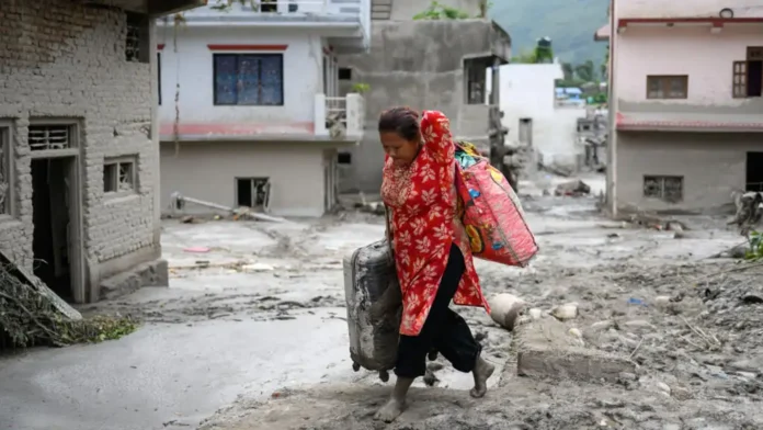
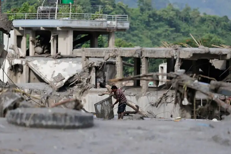
The 2026 Nepal-China flood disaster was triggered by a glacial collapse and debris avalanche in the Himalayas, which sent ice, rock, sediment and water into the river system. The resulting debris flow and flash flooding traveled downstream, destroying homes, bridges, roads and critical infrastructure in parts of Tibet and Nepal.
The Nepal-China flood disaster of August 26, 2026 was not simply a conventional monsoon flood. Current scientific assessments indicate that a glacial collapse and debris avalanche in the high Himalayas triggered a sudden surge of water, ice, rock and sediment, which then traveled through the Lhende/Lende River system toward the China-Nepal border and into Nepal’s Bhote Koshi and Trishuli river corridors. The event devastated settlements, roads, bridges, border facilities and hydropower infrastructure across a large area. The U.S. Geological Survey estimates that the debris flow and flood traveled approximately 100 km.
As of August 30–31, 2026, the reported human toll had risen dramatically, with more than 730 deaths reported in Nepal and nearly 2,500 people missing, while China reported additional deaths and missing people in Tibet. Because rescue and identification operations are still underway, these figures should be treated as provisional rather than final. WHO reported that more than 10,000 households urgently needed relief and warned of injuries, unsafe water, diarrhoeal and respiratory disease, vector-borne disease and mental-health consequences.
Table of Contents

What caused the Nepal-China flood disaster?
The most important point is that the disaster appears to have developed through a cascade of mountain hazards, rather than from heavy rainfall alone.
The sequence can be understood as:
Glacial instability → ice/rock collapse → debris avalanche → temporary river blockage → sudden water release → extreme debris flow → downstream flash flooding
According to USGS analysis, the initial event occurred near the glaciated slopes of Langtang Lirung, a Himalayan peak approximately 7,200 metres high. The collapse generated seismic energy equivalent to a magnitude 5.2 event, which initially led to reports of an earthquake. Further analysis of seismic waves and satellite imagery showed that the signal was generated by a glacial collapse and debris flow, not an earthquake.
This distinction matters.
A normal river flood develops primarily because water accumulates faster than a river can carry it away. A debris avalanche flood can behave very differently. A huge mass of ice, rock and sediment can suddenly enter a narrow Himalayan valley, temporarily block a river, accumulate water behind the blockage and then release a powerful surge.
That combination can produce a flood that is:
- extremely rapid;
- heavily loaded with boulders and sediment;
- capable of destroying bridges and buildings;
- difficult to predict using conventional rainfall-based flood models;
- dangerous even on a relatively clear day.
The World Health Organization similarly reported that the flooding in Rasuwa followed a sudden surge into the Bhote Koshi River from the Tibet Autonomous Region of China, possibly associated with an upstream ice avalanche and temporary damming of the Lhende River. WHO emphasized that assessments were still continuing.
Where did the disaster happen?
The disaster affected a transboundary Himalayan river system, making it particularly complex.
On the Chinese side, severe impacts were reported around Gyirong County and the Gyirong/Rasuwagadhi border area.
On the Nepalese side, major impacts occurred along the Bhote Koshi and Trishuli river corridors, particularly in:
- Rasuwa
- Nuwakot
- Dhading
- Chitwan
- parts of Gandaki Province
WHO identified affected districts including Rasuwa, Nuwakot, Dhading and Chitwan in Bagmati Province and Gorkha and Tanahun in Gandaki Province.
The geographical setting greatly amplified the disaster.
Himalayan valleys are often narrow, steep and heavily confined by mountains. When a massive debris flow enters such a valley, the surrounding terrain can effectively channel the energy downstream rather than allowing it to spread immediately across a broad floodplain.
USGS satellite and geological analysis indicates that the event traveled nearly 100 kilometres, demonstrating how a high-altitude mountain collapse can become a major downstream disaster far from its original source.
Why was the flood so destructive?
The answer lies in the energy and composition of the flow.
A conventional flood may primarily consist of water. A debris flood can contain:
- water;
- ice;
- mud;
- sand;
- gravel;
- large rocks;
- trees;
- structural debris.
The resulting flow behaves more like a rapidly moving mixture of water and solid material.
As the avalanche descended, the moving ice and rock incorporated additional sediment and water. USGS explains that this process produced a fast-moving, far-traveling landslide and flood heavily loaded with boulders and rubble.
This helps explain why bridges, roads, homes and other infrastructure could be destroyed so rapidly.
A simplified disaster mechanism
| Stage | What happened |
|---|---|
| 1. High-altitude instability | Ice and rock became unstable |
| 2. Glacial collapse | A large mass detached from the mountain |
| 3. Debris avalanche | Ice, rock and sediment accelerated downhill |
| 4. River interaction | Material entered the Lhende/Lende river system |
| 5. Temporary blockage | Debris impeded normal river flow |
| 6. Sudden release | Water and debris surged downstream |
| 7. River amplification | More sediment and material were incorporated |
| 8. Downstream destruction | Communities and infrastructure were overwhelmed |
This is why describing the event simply as a “flood” does not fully capture what occurred.
Nepal-China flood death toll and missing people
The casualty figures are changing rapidly because rescue teams are still reaching isolated locations, bodies are being recovered and authorities are working to identify victims.
WHO’s August 30 update reported more than 730 deaths in Nepal and nearly 2,500 missing, based on national authorities’ latest information at that time.
Reuters subsequently reported that combined figures from Nepal and China indicated nearly 800 deaths and more than 3,000 missing, including foreign nationals.
The discrepancy between individual reports is important. It does not necessarily mean that one source is wrong. During a rapidly developing disaster, authorities may report different geographic areas, different times, recovered bodies versus confirmed identities, or preliminary missing-person lists.
Therefore, anyone publishing the casualty count should clearly state the date and source rather than presenting a single number as final.
Why were so many people reported missing?
Several factors made search and rescue exceptionally difficult.
1. Extremely rapid onset
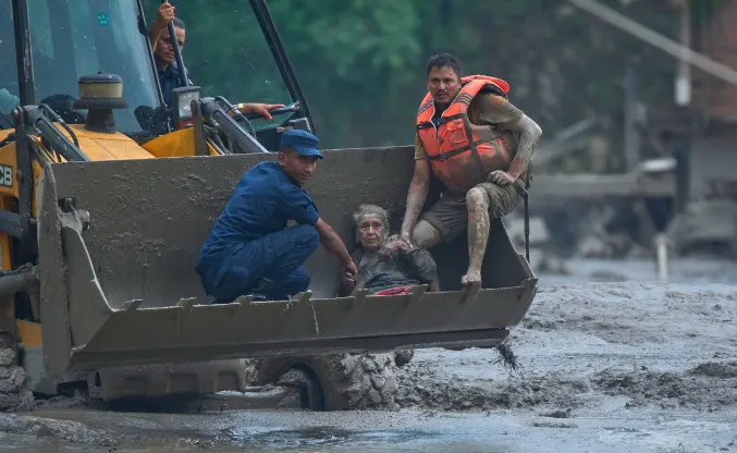
A conventional flood warning can sometimes provide hours of preparation. A debris avalanche may provide only minutes—or potentially no practical evacuation window for people directly in its path.
2. Destroyed transportation routes
Roads and bridges were damaged or swept away, making many communities difficult to reach.
3. Mountain terrain
Steep valleys restrict helicopter operations, ground access and the movement of heavy rescue equipment.
4. Damaged communications
Flooding damaged telecommunications and other infrastructure, making it difficult for families and authorities to establish whether people had escaped.
5. Hydropower facilities
Workers were present at hydropower facilities along the river corridor. Some people were reportedly trapped in tunnels or isolated by destroyed access routes.
6. International travelers
The Rasuwa-China corridor is also associated with travel toward Tibet and Mount Kailash. Foreign nationals were among those reported missing, adding a complex consular and identification component to the rescue effort.
What infrastructure was destroyed?
The disaster damaged much more than homes.
Reports indicate severe destruction involving:
- bridges;
- highways;
- border facilities;
- customs infrastructure;
- hydropower projects;
- electricity networks;
- telecommunications;
- markets;
- schools;
- health facilities;
- tourism-related businesses.
UNICEF reported that roads and bridges had collapsed, while hydropower, water and telecommunications networks were disrupted and health facilities were damaged.
WHO reported that several health facilities in the affected region were completely or partially damaged, while access to hospitals was also disrupted by damaged roads.
This creates a dangerous secondary effect: the disaster can continue to cause harm after the water recedes.
A damaged bridge is not merely an infrastructure problem. It can prevent:
- ambulances from reaching patients;
- food from reaching isolated communities;
- clean water from being transported;
- rescue teams from reaching survivors;
- electricity crews from repairing power networks.
What are the immediate health risks?
From a public-health perspective, the flood creates several overlapping emergencies.
WHO identifies the principal concerns as drowning and trauma, injuries, unsafe water and food, diarrhoeal and respiratory illnesses, vector-borne diseases and mental-health needs.
Unsafe drinking water
Floodwater can contaminate wells, pipes and surface-water sources with sewage, chemicals, animal waste and other contaminants.
People should not assume that apparently clear water is safe.
Diarrhoeal disease
Disrupted sanitation and contaminated water can increase gastrointestinal infections, particularly among children.
Injuries
Survivors may experience:
- fractures;
- lacerations;
- crush injuries;
- head injuries;
- hypothermia;
- drowning-related complications.
Respiratory problems
People exposed to dust, mud, contaminated environments and overcrowded temporary shelters may experience increased respiratory illness.
Vector-borne disease
Standing water and environmental disruption can alter mosquito breeding conditions and increase vector-related risks.
Psychological trauma
Loss of family members, homes, livelihoods and communities can produce severe psychological distress.
Disaster recovery therefore cannot be defined solely by rebuilding roads. Mental-health support and restoration of basic healthcare are also part of recovery.
What is WHO doing?
WHO has activated health emergency support alongside Nepal’s government and humanitarian partners.
As of August 30, WHO had:
- released US$150,000 through its South-East Asia Regional Health Emergency Fund;
- deployed emergency medical supplies;
- provided an Interagency Emergency Health Kit capable of supporting the health needs of nearly 10,000 people for three months;
- supplied multipurpose tents;
- supported disease surveillance;
- supported emergency medical teams;
- assisted coordination of health services.
WHO’s response demonstrates an important principle in disaster medicine: the first emergency is rescue, but the second emergency is preventing preventable disease and death among survivors.
What is UNICEF doing?
Children are particularly vulnerable after catastrophic floods because disruption affects not only food and shelter but also education, healthcare and protection.
UNICEF estimates that approximately 17,000 children need humanitarian assistance following the disaster. The organization is working with the Nepalese government and humanitarian partners to address disease, malnutrition, violence, exploitation and other risks affecting children.
For affected families, reopening schools can therefore become part of the recovery process—not simply an educational objective.
Could another flood happen?
Yes, authorities continue to treat the region as hazardous, but that does not mean another disaster of the same magnitude is inevitable.
This distinction is important.
After a major landslide or glacial collapse, debris can block waterways and create temporary lakes. If such a barrier fails, another flood pulse can occur.
Scientists and authorities have therefore been monitoring newly formed water bodies and unstable terrain.
The Stimson Center reported that new lakes had formed along the avalanche’s flow path and that authorities in Nepal and China were monitoring the situation. Its analysis also emphasized that possible secondary releases could vary substantially in size and behavior.
For people living downstream, the appropriate response is not panic but compliance with official evacuation and river-level warnings.
Is climate change responsible for the disaster?
The most scientifically accurate answer is: climate change may be an important risk multiplier, but it should not be described as the sole proven cause of this specific event.
The immediate physical trigger identified by USGS was a glacial collapse and debris avalanche.
However, warming of the Himalayan cryosphere can influence glaciers, frozen ground, snow and mountain slopes. Changes in these systems can alter the stability of high-altitude terrain.
Scientists therefore distinguish between:
Immediate trigger:
Glacial/slope collapse and subsequent debris flow.
Underlying environmental risk:
A changing high-altitude cryosphere and increasingly complex interactions between glaciers, rock slopes, water and extreme weather.
That distinction is essential for credible climate reporting.
It is scientifically stronger to say that climate change can increase or modify certain mountain hazards than to claim that every individual flood is directly “caused by climate change.”
Why was there not an earlier warning?
This is one of the most important questions surrounding the disaster.
The absence of a warning does not automatically demonstrate that authorities ignored a known danger.
USGS’s assessment indicates that the initiating event was exceptionally sudden and originated in a difficult-to-monitor high-altitude environment.
The Stimson Center similarly described the source region as a monitoring blind spot and emphasized that the speed of the event created fundamental challenges for conventional early-warning systems.
Traditional flood-warning systems often rely on:
- rainfall measurements;
- river gauges;
- weather forecasts;
- known glacial lakes;
- satellite monitoring;
- historical flood patterns.
But a sudden ice-rock collapse followed by a debris-dam failure can occur faster than conventional monitoring networks can detect, interpret and communicate the threat.
This disaster therefore highlights an important technological challenge:
Early warning must evolve from simply monitoring water levels to monitoring the entire mountain system.
That includes glaciers, unstable rock slopes, temporary lakes, seismic signals and rapidly changing river channels.
What should Nepal and China do next?
The disaster demonstrates why transboundary disaster cooperation is essential.
A river does not stop at an international boundary.
If a hazard begins in one country and affects communities in another, effective risk reduction requires information to move across the border quickly.
Priority measures should include:
1. Shared real-time monitoring
Nepal and China could strengthen joint access to:
- river gauges;
- satellite imagery;
- seismic monitoring;
- glacier observations;
- lake-level measurements;
- rainfall data;
- automated warning systems.
2. Joint hazard mapping
Maps should identify not only conventional floodplains but also:
- unstable slopes;
- debris-flow corridors;
- glacial lakes;
- potential landslide dams;
- critical infrastructure downstream.
3. Faster cross-border communication
Emergency agencies should have predefined channels for transmitting alerts without waiting for lengthy diplomatic procedures.
4. Infrastructure redesign
Bridges, roads, hydropower facilities and border infrastructure in high-risk valleys need to account for debris flows, not merely ordinary river flooding.
5. Community-level evacuation planning
A sophisticated satellite system is useless if communities do not know what an alert means.
Residents need clear instructions:
Where do I go?
How quickly must I leave?
Which route is safe?
Where is the nearest high ground?
What can the Nepal-China disaster teach the rest of the Himalayas?
Perhaps the most important lesson is that mountain disasters are becoming increasingly difficult to categorize into a single hazard type.
A glacier problem can become a landslide.
A landslide can block a river.
A blocked river can create a temporary lake.
A lake breach can create a flash flood.
The flood can destroy a bridge.
The destroyed bridge can prevent medical evacuation.
That is a cascading disaster.
Understanding this chain is more useful than simply asking whether an event was a flood, landslide or glacier disaster.
The Himalayas contain enormous amounts of ice, steep terrain, rapidly flowing rivers and densely concentrated infrastructure in narrow valleys. That combination means that even a relatively localized high-altitude failure can produce consequences far downstream.
The 2026 Nepal-China disaster is therefore not only a humanitarian tragedy. It is also an important case study in climate risk, cryosphere science, disaster medicine, early-warning technology, infrastructure resilience and transboundary emergency management.
Nepal-China Flood Disaster 2026: Key Facts at a Glance
| Question | Current assessment |
|---|---|
| When did it happen? | August 26, 2026 |
| Where? | Nepal-China Himalayan border region |
| Primary affected areas | Rasuwa, Nuwakot, Dhading and other downstream districts; Gyirong area in Tibet |
| Likely trigger | Glacial collapse/debris avalanche |
| Was it simply a monsoon flood? | No; evidence indicates a cascading mountain-hazard event |
| How far did the flow travel? | Approximately 100 km according to USGS |
| Initial seismic signal | Equivalent to M5.2, but determined to be a glacial collapse/debris flow rather than an earthquake |
| Nepal deaths reported by Aug. 30 | More than 730 |
| Nepal missing reported by Aug. 30 | Nearly 2,500 |
| Households needing immediate relief | About 10,000 |
| Children needing humanitarian assistance | Approximately 17,000 |
| Main health risks | Trauma, unsafe water, diarrhoeal disease, respiratory illness, vector-borne disease and psychological distress |
Figures remain provisional because rescue, recovery and identification operations are continuing.
FAQs
What happened in the Nepal-China flood disaster of 2026?
A high-altitude glacial collapse triggered a massive debris avalanche and subsequent flash flooding across the Nepal-China Himalayan border region on August 26, 2026.
Was the Nepal-China disaster caused by an earthquake?
No. Although seismic signals initially suggested an earthquake, USGS analysis determined that the signal was generated by a major glacial collapse and debris-flow event.
How many people died in the Nepal-China floods?
The reported death toll changed rapidly as rescue operations continued. By August 30, more than 730 deaths had been reported in Nepal, with additional casualties reported in China.
Why was the flood so destructive?
Unlike an ordinary flood, the event involved enormous quantities of ice, rocks, mud and sediment. This debris-laden flow had substantial destructive force and traveled a long distance downstream.
Which areas of Nepal were affected?
Rasuwa was among the hardest-hit areas, with downstream impacts also reported in Nuwakot, Dhading, Chitwan and other areas along the affected river corridors.
Conclusion
The 2026 Nepal-China flood disaster was a catastrophic transboundary Himalayan event initiated by a glacial collapse and amplified through a chain of debris-flow and river processes. The scale of destruction cannot be explained by ordinary flooding alone.
Its significance extends beyond the immediate death toll. The disaster exposes the vulnerability of communities, hydropower facilities, transportation corridors and health systems built within steep Himalayan valleys. It also demonstrates why future disaster preparedness must integrate glacier monitoring, landslide detection, satellite observation, river forecasting, rapid public communication and Nepal-China cross-border cooperation.
For affected communities, the immediate priorities remain straightforward: find missing people, provide medical care, restore clean water and communications, protect displaced families, and prevent secondary disease and flooding.
For scientists and policymakers, the larger lesson is more complex: the Himalayas require disaster-warning systems designed for cascading hazards, not isolated floods or landslides.
The most reliable information should continue to come from Nepalese authorities, Chinese authorities, USGS, WHO, UNICEF, ICIMOD and other recognized scientific and humanitarian organizations as the situation develops.




 and then